
Elevation Earth
Description
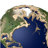
Explore your planet like you never imagined! A quick and fun way to learn about our Earth’s terrain from the depths of the oceans to the highest elevations.
- Displaying labels for countries, U.S. states, and Canadian provinces.
- Showing North and South Pole axis lines to keep better track of your orientation.
- Adjust the colors used at different elevations using a slider.
- Added new coloring option to easily see elevation contours.
- Control the elevation scale using a slider with more options and the ability to view elevations inverted with a negative elevation scale.
- Allow elevation scale to automatically adjust based on your zoom level, or keep it fixed to get an accurate view of the relative heights of geographic features
- Water level can be adjusted with a precision greater than the feet/meters displayed.
- Performance improvements
-
Full 3D interactive model of the Earth
-
Apply different levels of elevation exaggeration, providing a clearer view of the Earth's terrain
-
Alter the sea level by changing the amount of water on the Earth
-
Fully 3D animated sea level change
-
Color the land and sea with many different options, including satellite imagery, translucent sea and elevation dependent coloring
-
Tour over 300 different locations of elevation interest around the globe
-
Share you hi-res imagery with your friends via email, messages, Facebook and more
Product ID:
XP9CDC4819K77D
Release date:
0001-01-01
Last update:
0001-01-01