
Description
Let your imagination run free with our mysterious red neighboring planet. A quick and fun way to learn about Martian terrain from its deepest canyon to the highest planetary peak in the solar system. Create and share stunning imagery from any angle and location, color and elevation exaggeration. Familiarize yourself with the Martian globe to the extent that you can point out features to others unaided.
Features:
High-resolution 3D topographic model of Mars.
Use simple gestures to control zoom, pan, rotation and tilt of your Mars view.
Create stunning images from any angle and zoom.
Choose from a variety of color schemes to provide impressive renderings of any part of the surface of the Mars.
Color schemes include
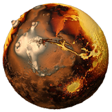
Satellite imagery, actual NASA satellite imagery
Yellow, dusty array of colors
Red, layers of colors in the red range
Vivid, strong colors with lots of contrast
Layers, many different color ranges that show off
Terra form, colors that imitate what would happen as the planet was being terraformed
Tour over80 important features including Landing sites, Mountains, Canyons, Craters, Plains.
With also over 1000 labeled locations.
Use the exaggeration option to increase difference between the high and low points on the Earth. This exaggeration helps to emphasize the true beauty and extremes of the terrain on a planetary scale.
Use the info window to display the imaginary amount of water area and volume on the Mars and watch it change dynamically as you alter the water level.
Adjust an imaginary sea level and amount of water on the Mars, watching it flood or drain areas of the terrain based on its elevation.
Share your high resolution imagery with friends via email, messaging, Facebook etc.
Direct link to Wikipedia information about the current location.
Help documentation included in app.
Full 3D navigation - View Mars from any angle.
Choose from a number of color palettes.
Display satellite imagery.
Control the colors displayed at different elevations.
Increase and decrease the exaggeration of the elevation.
Show how Mars would look with water from the Earth’s oceans and seas.
Learn about the water held in Ice and Rock.
-
3D Topographic Model of Mars
-
Fully 3D rotation and view manipulation
-
Raise and lower an artificial water level
-
Select from a number of elevation coloring options
-
Share imagery with your friends